Project Description
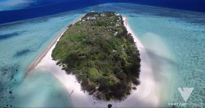
Turtle Surveying – Heron Island.
A better Vantage Point.
A better Vantage Point.
CASE STUDY
Turtle Surveying
– ECOLOGICAL & CONSERVATION RESEARCH GROUP
The use of satellite systems and manned aircraft surveys for remote data collection has been shown to be transformative for sea turtle conservation and research by enabling the collection of data on turtles and their habitats over larger areas than can be achieved by surveys on foot or by boat. Unmanned aerial vehicles (UAVs) or drones are increasingly being adopted to gather data, at previously unprecedented spatial and temporal resolutions in diverse geographic locations. This easily accessible, low-cost tool is improving existing research methods and enabling novel approaches in marine turtle ecology and conservation.


“Vantage Drones has acted as a contractor for various RPA works for the Department of Biological Sciences and beyond. Due to my understanding of their works and professionalism, I have recommended Vantage Drones several times….”